Issued at 1100 AM AST Mon Jul 01 2024
000
WTNT42 KNHC 011457
TCDAT2

Hurricane Beryl Discussion Number  12
NWS National Hurricane Center Miami FL       AL022024
1100 AM AST Mon Jul 01 2024

Satellite and radar data this morning suggest Beryl has completed an
eyewall replacement cycle. Radar images from Barbados show a solid
ring of deep convection surrounding the warming, well-defined eye of
the hurricane. Data collected by the NOAA and Air Force Hurricane
Hunters this morning confirm that Beryl has strengthened. Dropsondes
indicate the central pressure has fallen to around 956 mb, and the
earlier flight-level winds and SFMR data supported an intensity of
around 115 kt a couple of hours ago. The hurricane's satellite
structure has continued to improve this morning, and recent
objective satellite estimates justify raising the initial intensity
to 120 kt. The core of the powerful hurricane is nearing Carriacou
Island, Grenada, and the Grenadine Islands, where conditions are
rapidly deteriorating and residents should take action to protect
their lives.

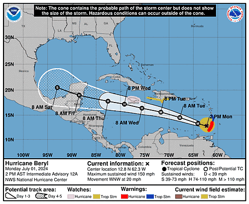
Aircraft and radar fixes indicate Beryl has jogged northwestward
over the past several hours, and the initial estimated motion is
west-northwest or 285/17 kt. The hurricane is currently moving
across the southern Windward Islands. A mid-level steering ridge to
the north of Beryl should steer the hurricane quickly
west-northwestward to westward across the Caribbean Sea during the
next few days as a mid-level ridge strengthens to the north of the
cyclone. This portion of the track forecast is very similar to the
previous advisory, and the NHC forecast remains close to the
multi-model consensus aids. At days 3-5, there is some increased
spread in the track guidance, likely regarding the strength of the
steering ridge as Beryl approaches the northwestern Caribbean Sea
and the Yucatan Peninsula. This portion of the forecast was nudged
slightly north of the previous one, but still lies south of the
consensus aids.

Since the eyewall replacement cycle has completed, the updated NHC
forecast allows for some additional near-term strengthening based on
recent aircraft data and the improved satellite and radar structure
of the hurricane. As previously noted, an increase in westerly shear
is expected by midweek, which is expected to induce some weakening
while Beryl moves across the central and northwestern Caribbean Sea.
This is reflected in the latest NHC prediction that follows the
multi-model consensus trends. Regardless, Beryl is forecast to
remain a powerful hurricane through late this week, and interests in
the northwestern Caribbean and the Yucatan Peninsula should continue
to monitor the latest forecast updates.

Based on the latest NHC forecast, the government of Jamaica has
issued a Hurricane Watch for the island.

Key Messages:

1. The eyewall of Beryl is moving through the southern Windward
Islands. This is an extremely dangerous and life-threatening
situation. Take action now to protect your life! Residents in
Grenada, the Grenadine Islands, and Carriacou Island should not
leave their shelter as destructive winds and life-threatening storm
surge are expected during the next few hours. Shelter in place
through the passage of these life-threatening conditions and do not
venture out in the eye of the storm.

2. Heavy rainfall and localized flash flooding are expected across
the Windward Islands through this afternoon.

3. Beryl is expected to remain a powerful hurricane as it moves
across the Caribbean Sea later this week. A Hurricane Watch has been
issued for Jamaica. Interests in the Cayman Islands, Belize, the
Yucatan Peninsula, and the remainder of the northwestern Caribbean
should monitor its progress. Additional watches and warnings will
likely be required during the next day or two.


FORECAST POSITIONS AND MAX WINDS

INIT  01/1500Z 12.4N  61.3W  120 KT 140 MPH
 12H  02/0000Z 13.3N  64.1W  125 KT 145 MPH
 24H  02/1200Z 14.5N  67.8W  125 KT 145 MPH
 36H  03/0000Z 15.6N  71.7W  110 KT 125 MPH
 48H  03/1200Z 16.4N  75.6W   95 KT 110 MPH
 60H  04/0000Z 17.2N  79.2W   90 KT 105 MPH
 72H  04/1200Z 17.8N  82.6W   80 KT  90 MPH
 96H  05/1200Z 19.0N  88.5W   65 KT  75 MPH...INLAND
120H  06/1200Z 20.5N  93.0W   55 KT  65 MPH...OVER WATER

$$
Forecaster Reinhart


